DURATION23 Days / 22 Nights
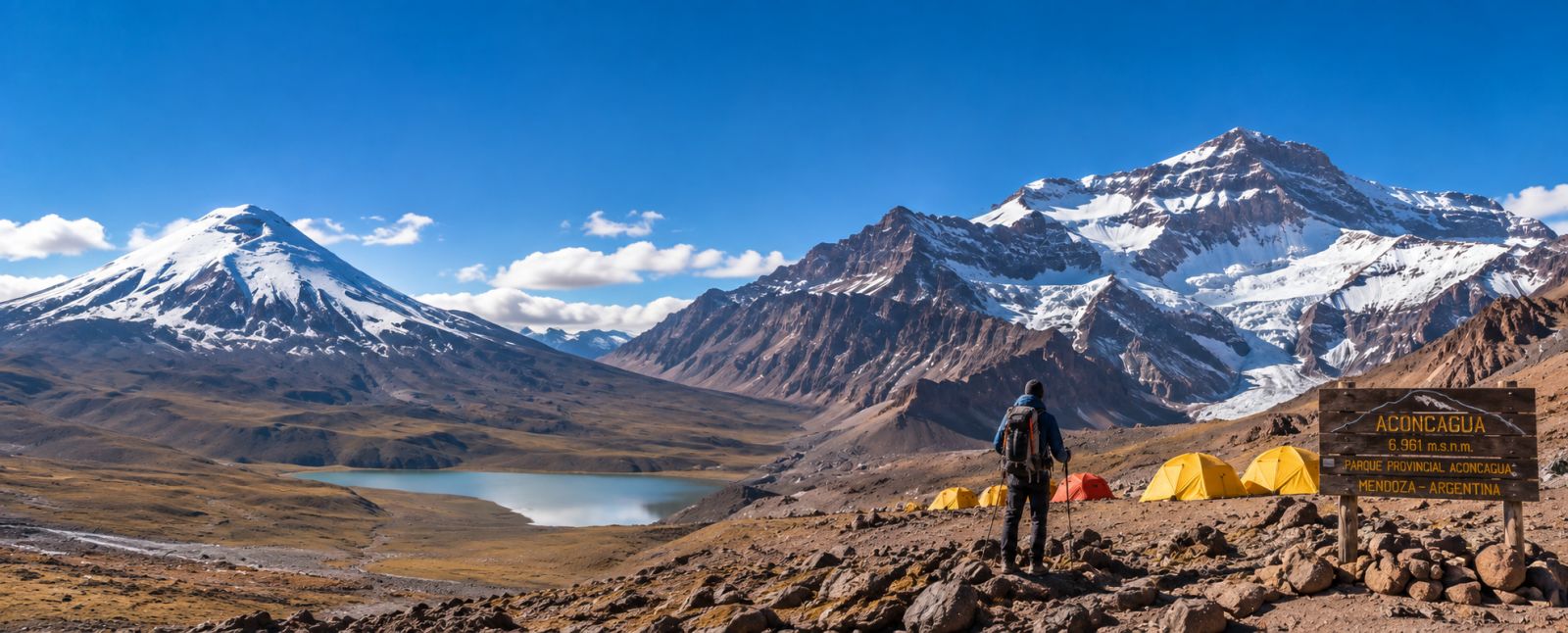
Climbing the Andes
23-Day Ecuador & Aconcagua Climbing Expedition
South America
PRICE FROM$6,290.00USD / Based on group
ABOUT THIS TOUR
Experience 23-Day Ecuador & Aconcagua Climbing Expedition
Climbing trip Overview!
When you arrive, EAI staff will pick you up at the airport and take X to the hotel for your first night in Quito. We will spend 9 days in Ecuador to properly acclimate for climbing the 5 summits along the Avenue of the Volcanoes, 4 in Ecuador and 1 in Argentina, the roof of America "Aconcagua" (6,962m/22,825ft)! The climb will begin in Ecuador with acclimatization at Pasochoa (4,199m/13,773ft), Guagua Pichincha (4,794m /15,724ft) or Ruco Pichincha (4,627m/15,176ft). E.A.I. proposes the following mountains to prepare for the "real" adventure climb: Iliniza North at (5,125m/16,810ft) and Cotopaxi volcano peak (5,897mt. The volcanoes of Ecuador are well known among climbers.
Cotopaxi Mountain Volcano is located Southeast from Quito on the central ridge of the Andes; Cotopaxi is the Ecuador's second highest peak. Cotopaxi Volcano is protecting for other small mountain like Rumiñahui other volcano peak how is good for acclimatization too on the West side from Cotopaxi, Sincholagua extinct volcano too on the North side of the Cotopaxi and Quilindaña rack peak how is on the Est para of the Cotopaxi, also this mountains is a particular because his rack composition is not Volcanic, looks like granitic rack hoe are very good for practice a climbing over the safe rack until to real the his summit.
Cotopaxi is very famous for his structure a perfect volcanic cone with perpetual glacier how live for millions year covered all the his structure volcanic covered the Snow Crevasses and Ice too, That to make to this mountain peak a very special to visit and climbing the most people how what to climbing even they don’t have any experiences on alpinism, but, the most people like to reach his crater summit, Cotopaxi volcano Is the very popular peak in Ecuador.
Our expedition to the highest mountain in Ecuador during the 12-days Itinerary, follows a through acclimatization program and glacier skills training, including climbing activity and a variety of technical equipment in a natural mountaineering environment.
The 24-day trip enables us to experience the landscape, culture and people of the Andean country. During the expedition, we climb 5 volcanoes. The first high objectives in Ecuador provide a good acclimatization before we move south on to Aconcagua in Argentina.
Ecuadorian Alpine Institute. Expeditions begin in the middle of the world in Ecuador, South America with beautiful volcanoes to get well acclimatized. Your expedition continues down South America follow to the Andes massive Mt. Aconcagua.
EAI guides arrange and get the permits for Aconcagua Provincial Park, that may take a day since the office only opens from 9 AM to 1 PM. Luckily the guide pre-pays the cost of each climber the day before to get the permits without any difficulty, so that we keep our regular itinerary.
Our team spends one or two wonderful nights in Mendoza after climbing to enjoying good food, plenty of wine etc.
NOTE THAT PLEASE: Aconcagua is not a trek only; it is a mountaineering expedition as well. Although it is a non-technical ascent, it is a long and extremely tiring climb at high altitude.
Follows the altitude on each mountain here below!
ACCLIMATIZATION: Pasochoa (4,199m/13,773ft)
ACCLIMATIZATION: Pichincha (4,794m /15,724ft)
ACCLIMATIZATION: Iliniza North (5,125m/16,810ft)
COTOPAXI CLIMBING VOLCANO AT (5,897mt /19,427ft)
CHIMBOARZO PEARK IS AT 6,263MT./ 2,0668ft.
We will be climbing this summit before going on to our next gold. ACONCAGUA MOUTAIN IS AT: 6,959m/22,825ft – THE ROOF OF THE AMERICA.
EXPEDITION ITINERARY ECUADOR-ARGENTINA - ACONCAGUA 24 DAY CLIMBING EXPEDITION TRIP.
5 BIGH SUMMITS ALONG THE AVENUE OD THE VOLCANOS.
When you arrive, EAI staff will pick you up at the airport and take X to the hotel for your first night in Quito. We will spend 9 days in Ecuador to properly acclimate for climbing the 5 summits along the Avenue of the Volcanoes, 4 in Ecuador and 1 in Argentina, the roof of America "Aconcagua" (6,962m/22,825ft)! The climb will begin in Ecuador with acclimatization at Pasochoa (4,199m/13,773ft), Guagua Pichincha (4,794m /15,724ft) or Ruco Pichincha (4,627m/15,176ft). E.A.I. proposes the following mountains to prepare for the "real" adventure climb: Iliniza North at (5,125m/16,810ft) and Cotopaxi volcano peak (5,897mt. The volcanoes of Ecuador are well known among climbers.
Cotopaxi Mountain Volcano is located Southeast from Quito on the central ridge of the Andes; Cotopaxi is the Ecuador's second highest peak. Cotopaxi Volcano is protecting for other small mountain like Rumiñahui other volcano peak how is good for acclimatization too on the West side from Cotopaxi, Sincholagua extinct volcano too on the North side of the Cotopaxi and Quilindaña rack peak how is on the Est para of the Cotopaxi, also this mountains is a particular because his rack composition is not Volcanic, looks like granitic rack hoe are very good for practice a climbing over the safe rack until to real the his summit.
Cotopaxi is very famous for his structure a perfect volcanic cone with perpetual glacier how live for millions year covered all the his structure volcanic covered the Snow Crevasses and Ice too, That to make to this mountain peak a very special to visit and climbing the most people how what to climbing even they don’t have any experiences on alpinism, but, the most people like to reach his crater summit, Cotopaxi volcano Is the very popular peak in Ecuador.
Our expedition to the highest mountain in Ecuador during the 12-days Itinerary, follows a through acclimatization program and glacier skills training, including climbing activity and a variety of technical equipment in a natural mountaineering environment.
The 24-day trip enables us to experience the landscape, culture and people of the Andean country. During the expedition, we climb 5 volcanoes. The first high objectives in Ecuador provide a good acclimatization before we move south on to Aconcagua in Argentina.
Ecuadorian Alpine Institute. Expeditions begin in the middle of the world in Ecuador, South America with beautiful volcanoes to get well acclimatized. Your expedition continues down South America follow to the Andes massive Mt. Aconcagua.
EAI guides arrange and get the permits for Aconcagua Provincial Park, that may take a day since the office only opens from 9 AM to 1 PM. Luckily the guide pre-pays the cost of each climber the day before to get the permits without any difficulty, so that we keep our regular itinerary.
Our team spends one or two wonderful nights in Mendoza after climbing to enjoying good food, plenty of wine etc.
NOTE THAT PLEASE: Aconcagua is not a trek only; it is a mountaineering expedition as well. Although it is a non-technical ascent, it is a long and extremely tiring climb at high altitude.
Follows the altitude on each mountain here below!
ACCLIMATIZATION: Pasochoa (4,199m/13,773ft)
ACCLIMATIZATION: Pichincha (4,794m /15,724ft)
ACCLIMATIZATION: Iliniza North (5,125m/16,810ft)
COTOPAXI CLIMBING VOLCANO AT (5,897mt /19,427ft)
CHIMBOARZO PEARK IS AT 6,263MT./ 2,0668ft.
We will be climbing this summit before going on to our next gold. ACONCAGUA MOUTAIN IS AT: 6,959m/22,825ft – THE ROOF OF THE AMERICA.
EXPEDITION ITINERARY ECUADOR-ARGENTINA - ACONCAGUA 24 DAY CLIMBING EXPEDITION TRIP.
5 BIGH SUMMITS ALONG THE AVENUE OD THE VOLCANOS.
YOUR JOURNEY
Itinerary
Arrival to Quito
Pick up in the airport transfer IN to your hotel available. Swissôtel.
ACCLIMATIZATION Pasochoa (4199m/13,773ft)
We depart at 8.30 a.m. towards the 30 km south of Quito located Cerro Pasochoa at 4199m.(13773ft) It is an ancient and highly eroded volcano which has been inactive since the last ice age. We drive until the car park from where we follow the track as it contours the eastside of the mountain heading towards the rocky peak. This easy ascent will take us 3-4 hours to reach the summit. Rest for one hour, lunch in this time, and coming down to the parking car for 2 hours hiking down, bay our car back to Quito in the afternoon. Swissôtel (B/BL)
Ruco Pichincha (4794m /15,724ft)
Hike up to Pichincha massif. We take our first acclimatization ascent on the 4794m (15,724ft) Ruco Pichincha is a very good mountain for beginning the process to acclimatize, we do have to rout here on this mountain one is just hike up the arrive at the hem summit, the other one is more interesting, you learn to climb but the Volcanic rack, we do climb direct for the reach of the mountain we do use rope for protect you for safe climb with the harness and pruxicks, on this way we do cross the dead pass, were is impressive to learn how you can make the difficult pass, after here you can go easy to the top. From this reach you can see the Quito City as well and other very nice panoramas to. Quito is nestled on the slopes of this beautiful Andes mountain. Our primary goal here is to help each team member begin testing his or her response to higher elevation and to give our bodies a chance to get used to altitude, while enjoying the many photographic opportunities. In the afternoon drive back to Quito. Swissôtel (B/BL)
Refugio ILINIZAS (4.600m/15,088ft)
After breakfast a mid-morning departure from Quito to Ilinizas and to the parking lot. We travel for the Panamericana high way, We passing for very nice and agriculture areas and very grin areas and many Volcanoes on front of us you can see nice view and good time for pictures too. We will be arrival a remote area called “paramo” that is to an area called la Virgén. From here it is 3 hours hike up to the refuge with our full back packing on us, the refuge is situated at 4,600m. Dinner and sleep in the refuge. (B/BL/D)
ILINIZA NORTE (5.125m/16,810ft)
Wake-up early in the morning at 5 AM. Breakfast. and departure for our 5,125m summit day attempt on Iliniza North. This peak is normally a fairly straight forward climb that sometimes requires for acclimatization days the trail on this mountain is send and Rock almost difficult for fine the way, if the water condition is bad with cloud for sure is very ease for last the way and last the person too.
On one part of the way we will be use a fixed rope for pass or negotiate "Death Pass." After this pass we have the summit. Three hours average to reach the summit. Pictures time, Lunch. Descent for one 1,1/2 to refuge, resting before to going down to the parking lot at our private car 4x4 transportation will take us to hotel near to Cotopaxi National Park for one hour driving and put on our hotel resting night. Tambopaxi hostelry. (B/BL)
On one part of the way we will be use a fixed rope for pass or negotiate "Death Pass." After this pass we have the summit. Three hours average to reach the summit. Pictures time, Lunch. Descent for one 1,1/2 to refuge, resting before to going down to the parking lot at our private car 4x4 transportation will take us to hotel near to Cotopaxi National Park for one hour driving and put on our hotel resting night. Tambopaxi hostelry. (B/BL)
COTOPAXI JOSE RIVAS HUT
To day we do have a mild morning resting on Tambopaxi. After a big Lunch in tambopaxi we can move up the Cotopaxi Refugio (4800m/15,744ft.) After arrival at the hut, we will enjoy a hot tea and a short rest before a training to the handling rope nuts, Pruxiks etc for safety climb in the mountains, rest, delicious dinner relax evening around 5:30pm. Of course we Prepare our mountain gear for a midnight departure for Cotopaxi day summit. Early dinner and early bed usually by 6:30 P.M.(B/BL/D)
Cotopaxi-summit (5897m/19,427ft)
Wake up at midnight. Breakfast and equipment check-up. We leave the refuge at 1:00 A.M. We will pass a group of uniform slopes and ice ramps of 30 and 35 degrees before reaching a glacier platform. We enjoy one of the spectacular color displays in the Andes. From this point we see the valley below us where the morning sunrise welcomes us with incredible colors. Our route will pass under a base of rock 400 feet wide called Yanasacha. The quichua name says it all, its a black wall of impressive size. The Indians called it the route of the moon. Here we start climbing glacier slopes of 35 and 45 degrees, at the top of which we will only have 15 more minutes climb to emerge onto Ecuador's second highest summit: Volcano Cotopaxi at 5897m/19,427ft.) Our approximate climbing time will have been 7 hours. Return to the refuge around 9 or 10:00 A.M. Rest and hike back down to our car park. Pick up our car and drive to Baños, Hosteria Monte Selva. (B/BL)
We relax in the mountain valley town of Baños
Where the lush vegetation is home of an unusual variety of orchids, butterflies, and hummingbird species. Visit to the zoo, etc. After lunch you have free afternoon. Accommodated at a fine hotel across Ines Maria waterfall, we will enjoy the natural hot water baths, sauna etc. Hosteria Monte Selva. (B)
Baños Chimborazo parking lot at 4800mt. Carrel Refuge
Depart from Banos at 11:00 A.M. Drive Northwest of Banos, passing the agricultural towns valleys from the Andes, we cross Ambato again. On all the way we crossing agricultural and indigenous areas, where a picture or two may attract you. After 4 hour’s drive we will arrive at the lower refuge of Chimborazo 4800m (14,545ft) Lunch here. Then we preparing our back packs to continue hike up the reach the high cam at condor mirador at 5300mt Altitude we need to hike up for 2 more hours from the parking lot we reach the high comp around 16h. Short rest, picture etc. until dinner time into the igloo tents. Short rest picture time if the weather condition is good, drink tea, café, chocolate, until the dinner is ready at 5h30pm. We have to sleep at the igloo tents to rest our body´s until 00H. Is time to stand up to eat mountain breakfast, preparing our gear to climb, and we leave out at 1 am. (Hike body´s) high Camp (B/BL/D)
IMPORTAN NOTE:
Whereas in the Chimborazo changes its geography much by weather conditions and erosion with its glaciers. I beg to report that since 2015, from that year we decided to organize the ascents with an altitude camp, from here we can hike up from the different accesses to meet the Normal route to the rock castle, (el Castillo) when the normal rout is without snow becomes very dangerous rock fall since the road are very steeper and thawed up to 5600m tall, to safety of all guests that come with EAI. We take the decision to do this variant route.
There is an extra cost 50 dollars per person, this is to cover the expenses of the porters who carry all your equipment, if you want? If not, you carry for 2hours all your gear until we reach the camp at 5348Mt. The night you will sleep at more height altitude. Those money you can pay if the service is used. Today all the climber uses this camp and route too.
IMPORTAN NOTE:
Whereas in the Chimborazo changes its geography much by weather conditions and erosion with its glaciers. I beg to report that since 2015, from that year we decided to organize the ascents with an altitude camp, from here we can hike up from the different accesses to meet the Normal route to the rock castle, (el Castillo) when the normal rout is without snow becomes very dangerous rock fall since the road are very steeper and thawed up to 5600m tall, to safety of all guests that come with EAI. We take the decision to do this variant route.
There is an extra cost 50 dollars per person, this is to cover the expenses of the porters who carry all your equipment, if you want? If not, you carry for 2hours all your gear until we reach the camp at 5348Mt. The night you will sleep at more height altitude. Those money you can pay if the service is used. Today all the climber uses this camp and route too.
Chimborazo Summit – Estrella del Chimborazo
Chimborazo is Ecuador's highest peak and a massive glaciated volcano, that consists of five summits. Rise at midnight for breakfast and equipment check-up. Leave the hut at 1:00 AM. We move immediately to the huge glacier on Chimborazo's southwest face, where we first traverse moderately angled ice slopes, climb through a series of icefalls and up to the steep ice ramps. Climbing simultaneously on moderate grounds belaying up the steep pitches. Our team will rope together in order to cross crevasses and finally make it to the summit. This is the highest point of the Andes, and from here we have a magnificent view of the emerging volcanoes that form the eastern and western Cordillera. The mentioned volcanoes seem to emerge from the clouds below our feet. Our approximate climbing time is 8 to 9 hours. Return to the refuge around noon. After short rest in the Hut, packing the back packs to drive back to Quito. Arrive in Quito around 7-8pm Swissôtel. (B/BL)
Resting full day In Papallacta HOT SPRINGS
The hydrothermal value of Termas de Papallacta's Hot Springs is thanks to Papallacta's location between two volcanoes, Volcano Cayambe and Volcano Antisana. The source temperature of the thermal baths varies between 30°C and 70°C (86°F and 158°F). At the pools the temperature ranges from 36°C to 40°C (97°F to 104°F). Papallacta´s thermal waters contain sulfates, sodium, calcium, chloride and traces of magnesium which are odorless, colorless but have a slightly salty taste. Besides improving intestinal function, the baths' curative properties are also anti-allergenic, anti-inflammatory, diuretic and anti-rheumatic. Ecuadorian Medical Federation. After Lunch at 3pm we coming back to Quito for take the flight down to Mendoza. From Quito flight to Mendoza in the evening we do leave around 9:45pm. Arriving in Mendoza 11:30am on day 10, transfer IN with EAI guide. (B)
FLY QUITO TO ARGENTINA, CHILE – AND TRANSFER IN TO MENDOZA - PERMITS ARRANGEMENT FOR ACONCAGUA PROVINCIAL PARK - PUENTE DEL INCA.
Today we can make the transfer into Mendoza city. EAI expeditions tour leader will finalize the papers to enter to Aconcagua Provincial Park. Here, we must complete our applications to enter the park. Ecuadorian Alpine Institute meets all permit charges, so all you will need is your passport, a copy of your insurance certificate and a pen. Once these minimal formalities are completed, we may continue our drive! Immediately we take our private mini bus to drive 2 hours to Uspallacta Village, which is on route N 7, to have lunch at a very good restaurant (Don Pato) featuring delicious local cuisine (Beef de Chorizo with red Wine) or other very good local cuisine. Around 5:00 P.M. we leave Uspallacta to drive another 2 hours to Puente del Inca, arriving around 7:00 P.M. We stay at a hotel in Puente del Inca. The altitude here is 2,800m (9,186ft), the same altitude as Quito. We have dinner here and rest for the night. From Mendoza to Puente del Inca, it's a 4-hour drive, 180 Kilometers on route N 7; this route goes to Chile as well.
HOSTERIA PUENTE DEL INCA RESTING FULL DAY. SWIMMING AT THE THERMAL POOL. CHECK IN ON THE ORNOES GUARDA PARQUES
Hosteria Puente del Inca was built in 1925, at the time a luxury place available only for the most important personalities. On the way to Las Cuevas (the border with Chile) you can enjoy this curious geological formation at one of the most famous hot springs resorts of Argentina. Bathing in these waters is recommended for many different conditions, and added to the uniqueness of this natural monument and surrounding landscapes, Puente del Inca is a unique place, located on the Cordillera de Los Andes, 2800 meters above the sea, Puente del Inca is famous for its natural bridge, declared a Natural Monument, and unique geological features. The bridge has been formed by the action of mineral waters. The river flow is pushed through sediments deposited at the bottom and then hardened by the hot springs. This gives the area it's colors of oranges, yellows and ochres. The history of the bridge begins with the Inca Trail and their legends. It is assumed that it was known and frequented by this culture to harness the waters healing properties. Its fame is mainly due to its thermal baths. There are buildings on the side and under the bridge with small pools where the water forms hot springs, which come from natural springs. In the morning you can go to swim, take a small hike, etc. You can feel free resting half a day, or you have time to check your personal climbing gear. After lunch, around 2:00 P.M., our tour leader meets you to prepare everything for the next big day. All members of the group go up to the Horcones entrance with your permits to CHECK IN, because the next day we can begin to hike at 7:00 A.M. from the Horcones control gate. From Hosteria Puente del Inca to Horcones is 3km. We can hike or drive there, and come back to the hosteria the same way. Immediately, we'll sort out our bags for the mules, as these will be taken early the next morning and delivered to Plaza de Mulas, our next stopping point at base camp. We end the day with dinner and head to bed.
PUENTE DEL INCA - HORCONES - CONFLUENCIAS - PLAZA DE MULAS
We get up for breakfast at 6:15 A.M. We catch a private car from Hosteria Puente del Inca to the Horcones Guarda Parques entrance, where we already checked in the day before. This day we begin our approach to Aconcagua. Mules will carry all of our expedition food and equipment, enabling us to enjoy this spectacular day hike with a light day pack. The trail follows the Horcones River to the junction of the Lower and the Upper Horcones River. After crossing the Lower Horcones on a footbridge, we continue up the river valley towards Confluencia, 3,400m (11,155ft), where we'll pass this intermediate camp. From Horcones to Confluencia we'll hike about 2 and a half hours. In Confluencia we have an hour to rest, drink a hot café, then continue our long route. While other climbers spend three nights at Confluencia in order to adequately acclimatize for climbing Aconcagua, EAI groups arrive here with very good acclimatization from Ecuador after climbing Mt. Volcano Cotopaxi at 5,897m (19,347ft). This is a tough day - taking about 11-12 hours to reach the base camp Plaza de Mulas. We start relatively early at 7:00 A.M., armed with no less than 4 liters of water per person, as the valley that stretches ahead is hot and dusty, even though a river runs across the wide plain of the valley floor. After 4 hours walking along a very gentle rise, and avoiding river crossing, if possible, in order to keep our boots dry, the valley splits, and the route swings to the right (north). Here, we rest for lunch and prepare for the sudden rise in altitude that will accompany the afternoon's stroll. The path rises steeply to complete the hardest day of the expedition, so far. By the time we land in Plaza de Mulas, we will have climbed nearly 1,481 meters during the day. We settle into our base camp tents at Plaza de Mulas base camp 4,200m (13,779ft), and get to know the local staff, who will support us from this point on.
AFTER THE LONG JOURNEY WE HAD THE DAY BEFORE, YOU NEED TO RECOVER ALL THE ENERGY (RESTING FULL DAY)
Today is just for resting the full day and recovering our energy at the new altitude on Aconcagua, at Plaza de Mulas base camp at 4,200m (13,779ft). A day off allows everyone to readjust and to get ready for the ongoing climb upwards. EAI will supply you with breakfast, lunch and dinner every day we are in the base camp. Hot drinks will be provided regularly as well as water. In the afternoon the expedition leader will prepare a list of what to take. At the same time, equipment will be prepared for the local porters to carry, which ensures you will only have to carry your own personal equipment, with all the group’s stores and food being taken by the porters who support the team. We'll spend the night at base camp Plaza de Mulas.
Hike to Camp 1 Nido de Condores at (5,559m/17,100ft)
After breakfast, we leave the base camp Plaza de Mulas at 9:30 A.M. We take our food and gear to leave at Nido de Condores Camp and prepare the logistics at Camp 1 for the next day's expedition on the very high altitude before attempting the summit. Today we carry gear up towards Camp 1, 5,559m (17,100ft). From our base camp in Plaza de Mulas, we follow the trail as it gradually suitcase from steep screen slopes to the rock spires that mark Canada Camp at 5,000m (16,500ft). We pass Canada Camp and head up to Nido de Condores, our next camp 1. This usually takes 5-6 hours. We set up the tents and you'll have time to take great photos. If the weather conditions are good, you can see the sun set like in the ocean. We have dinner at high altitude and stay overnight at Nido de Condores to measure our acclimatization before going to our next high camp 2 Colera at 5,890m (19,437ft)
Breakfast at Nido de Condores
Hike down to base camp Plaza de Mulas. Today is just to measure how our body is acclimitizing after we spent the night at high altitude. Around 11:00 A.M. we can move down to Plaza de Mulas for a resting afternoon and to recover our energy. We'll stay overnight at base camp Plaza de Mulas.
Plaza de Mulas – Nido de Condores – Camp 2 Colera - 8 hours hike up
After breakfast we can move out at 9:00 A.M. to arrive at our Camp 2 COLERA, which is a bit higher than Berlin camp. Colera camp is located at 5,970m (19,569ft), 40 meters higher than Berlin Camp. Today we can make our first foray onto the mountain; from Plaza de Mulas to Colera we climb 1,600m (5,249ft). In the first 3 hours of climbing we pass Canada Camp, continue our climbing, we pass slope changes and from here we take another hour to arrive at Nido de Condores. We rest a short time her to eat and drink then continue our climb for another 3 hours. We follow the head trail up through the same route to Berlin camp towards many switchbacks, here you hike more slowly, you may feel low oxygen as well. From Berlin Camp, we cross just the last traversed part. After climbing a nice rimaya rack we get to the Colera Camp, where our tents are ready, for spending the afternoon resting. This is a really useful day, and past experience has shown that by sleeping on the mountain at high altitude, our acclimatization will be given a huge boost that will enable us to tackle the mountain with more energy and less difficulty. We have dinner and spend the night at Camp 2 Colera at 5,970m (19,569ft).
The EAI Leader checks the weather every day with the park authority by radio. If the weather conditions are confirmed by Aconcagua Park, the next day we can move up to make the Aconcagua Summit. If so, we can prepare all the personal gear in the afternoon for the next morning's climb.
The EAI Leader checks the weather every day with the park authority by radio. If the weather conditions are confirmed by Aconcagua Park, the next day we can move up to make the Aconcagua Summit. If so, we can prepare all the personal gear in the afternoon for the next morning's climb.
Summit attempt to Acocncagua
We wake up at 4:00 A.M. to check the weather for the day. If the EAI leader and guides agree to go, then everyone needs to get ready for the big day. After breakfast, we should start no later than 5:00 A.M. From Colera camp, we begin climbing up the regular switchbacks, after 45 minutes we can meet the way coming from the Berlin camp. Here we may join many other climbers. Around 6:15 A.M. the sunrise brings a very magnificent view of the Andes. Continuing up at a slow hike, after many other switchbacks we come to another hut (Independencia camp) at 6,377m (20,921). From here, the route crosses the side of the mountain over screens to break out at the start of the traverse that leads to the foot of a large gully, leading down from the Summit Ridge. Sometimes from Independencia we need to put on our crampons, the entire route is packed with snow. After crossing the side, immediately we hike on the traverse and come to a rock that looks like a gendarme. This rock is the sentinel that watches the traverse and the beginning of the canaleta as well. After crossing the sentinel, we climb for long time up. This is the Canaleta, which is the most strenuous climbing. Eventually it leads to the Summit Ridge and amazing views straight down the south face of Aconcagua. A 35-minute traverse leads across rocky ground and a well-defined path to a short scramble immediately below the top. This lead, without difficulty, to the final steps that lead to the small summit plateau. Here, a cross marks the highest point in the western and southern hemispheres. Between Nido de Condores to Aconcagua Summit, we climb 1,399m. We take around 8-9 hours climbing up and 4-5 hours climbing down. After we reaching the summit take us a big hug to celebrating the ascent and taking many photographs for the souvenirs, after same rest we descent for the same using the normal route passing the Independencia Camp again to arrive at Colera, where our tents are here we have dinner and spend the last night in the high altitude.
Second day to summit attempt
This day is scheduled for resting only and preparing for our next long summit day push. We spend the day at Colera Camp 2. For EAI groups this is a Summit Bid Day. We have two days to reach the summit. This gives us spare time in case of bad weather, but the summit will be attempted on the first day if possible. With an early start, the summit is attainable in about 8 hours.
Two summit days have been scheduled into the itinerary in case of bad weather in any part of the climb. In addition, day 18-19 can also be used as an alternate summit day if climbers require.
Two summit days have been scheduled into the itinerary in case of bad weather in any part of the climb. In addition, day 18-19 can also be used as an alternate summit day if climbers require.
Last night on the Andes Mountain
This day, we'll wake up tired but elated. Unlike the previous day, we can afford to let the sunlight bathe and warm our tents before we get up for breakfast. However, once up, it will be a race to get ready and to make a rapid descent down to base camp, where the staff will be waiting to share the excitement of our ascent. We should all have returned to base camp by mid-afternoon at the latest, which will give us plenty of time for a shower, relaxing and preparing our bags for the walkout. Our final lunch and dinner will be special and no doubt accompanied by beer and wine to have a nice celebration.
We spend the last night at Plaza de Mulas.
We spend the last night at Plaza de Mulas.
Resting full day at Plaza de Mulas
After the summit day we have a full day to rest at Plaza de Mulas, recovering our full energy for the next day hiking back down.
Exit National Park and return to Mendoza
Today is a long day's trek all the way down the Horcones Valley to the National Park entrance. We will need to start early today (no later than 9:00 A.M., if possible) in order to make the journey all the way back to Mendoza. The walk will take about 8 hours, with little time to linger over lunch. After arriving back at the gate, at about 4:00 P.M., we then have a 4-hour drive back to town, where we would expect to be back in the hotel in time for a quick turnaround and shower before having dinner at a restaurant at about 9:00 P.M., along with our local guides to celebrate our expedition. (Which is when the locals go out to eat anyway.) At RESTAURANTE FRANCIS, you'll enjoy very good Argentinean cuisine.
Fly from Mendoza to Buenos Aires or Santiago de Chile Back to home
Today, we fly from Mendoza to Buenos Aires to an hotel right at the center of the city. This gives very quick access to the main shopping areas. Buenos Aires in Argentina and Santiago de Chile in Chile are the largest cities in South America and the largest Spanish-speaking cities in the world. According to peoples' wishes, the leader can arrange a city sightseeing tour or a guided visit to a local ecological reserve. After a full day, in the early evening, we leave to the airport to catch our flights back home. (If your flight is not too early.)
WHAT'S INCLUDED
Included
- Hotels accommodation in Ecuador & Argentina (7 Night at double bead with American Breakfast) (as described on the Itinerary)
- Bilingual certified Mountain guide.
- All private transportation.
- All meals while on the climbing trip. (B./BL./D.)
- Porter for the group gear.
- All tents, cooking gear for the climbs.
- Rope and techniques climbing gear.
- Mules for carry the gear at high camp, and down.
- Climbing permits In Ecuador.
PLEASE NOTE
Not Included
- All International round-trip airfares.
- Aconcagua Park fees.
- Additional hotels, meals and transportation should the climb end early.
- Meals, hotels and transportation outside the regular itinerary.
- Personal gear.
- Single-room supplement for hotels.
- Medical/Evacuation trip insurance.
- Charges incurred as a result of delays and itinerary changes beyond the control of Ecuadorian Alpine Institute. We recommend travel insurance to cover any unforeseen costs.
- Tips and gratuities
- Alcohol and/or bottled drinks.
- Personal porters support. (for $.1000 Dollars.)
GOOD TO KNOW
Important Information
- Looking to schedule alternate dates to fit your goal.
- Ecuadorian Alpine Institute offers you a customized trip and customized itineraries to all South America with our exotic destinations.
- Ecuadorian Alpine, recommend you to acclimatize in Ecuador first to take this wonderful Adventure climb.
CAPTURED MOMENTS